
Millennium Parking
As brother Jeff and I have conducted our (lackadaisical) search for an apartment to share, I have been spending plenty of time in Google Maps/Earth. While my knowledge of Chicago’s streets has improved by leaps and bounds in the past year, I still need the frequent assist in the form of a nice satellite photo. Jeff, on the other hand, has so much ground-level Chicago experience he could give the Google Maps team corrections*. He warned me the sat photos were sometimes well out-of-date.
How right he was. Just yesterday I pulled up the following map of a Chicago landmark:
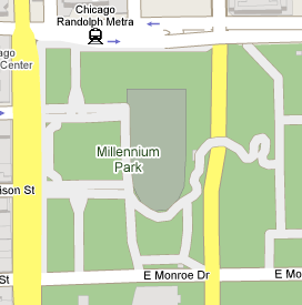
Note in particular the distinctive squiggly shape. Now check out the satellite version:

Wait, where’s the squiggly thing? That just looks like a big parking lot. And therefore we know this photo was taken before Millennium Park opened in July 2004. Well before, presumably, because the “squiggly” is actually the Frank Gehry-designed 925-foot pedestrian bridge across Columbus Drive, shown here from another angle:

Of course, even at 3 years old I’ll take what I can get. Beats getting up out of my chair in a Chicago winter.
*No, really. Even now, one block of the very street upon which he used to live is incorrectly marked as an eastbound one-way. Technically a NAVTEQ problem, but still…
March 3rd, 2007 at 2:59 am
Jesus CHRIST it’s about time you updated. Millenium Park is pretty. I went there two Octobers ago and played Frisbee with some teenagers/strangers. I like that reflecting sphere thing.
March 7th, 2007 at 7:55 am
The “Bean” AKA “Cloud Gate” is pretty awesome. I tried to find this article I read before that had a great explaination of how they made it but, well, no dice. I recommend looking into it, however, because it’s incredible how they managed to make it entirely chrome and seamless.
P.S. Thanks for the props.
Peace
JP