
Maps and Missiles Redux
Previously, I looked at Google Maps and noticed the top of the White House was altered, for security reasons. In Google Earth, the image looks the same, which is not surprising as they both draw from the same data.
But this puzzles me:
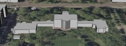
This is the same image of the White House, this time in Google Earth (larger screenshot, placemark) with a tilt and “extrude buildings” enabled.
As you can see, the 3-D model is a pretty good likeness, which makes me wonder: how is that possible? A recent Slashdorks article said Google was building a laser-equipped truck to scan buildings (and included a link to this fascinating project at Berkeley) but even if such a truck were in the wild, I don’t think they’d let it drive around the grounds of the White House.
Which leaves a few options: either there’s some kick-ass photogrammetry going on, or there are some other datasets in play here.
In any case, I’m fascinated.
Update [Thu 00:18]: Check out these cool placemarks. Not strictly related, but still cool.